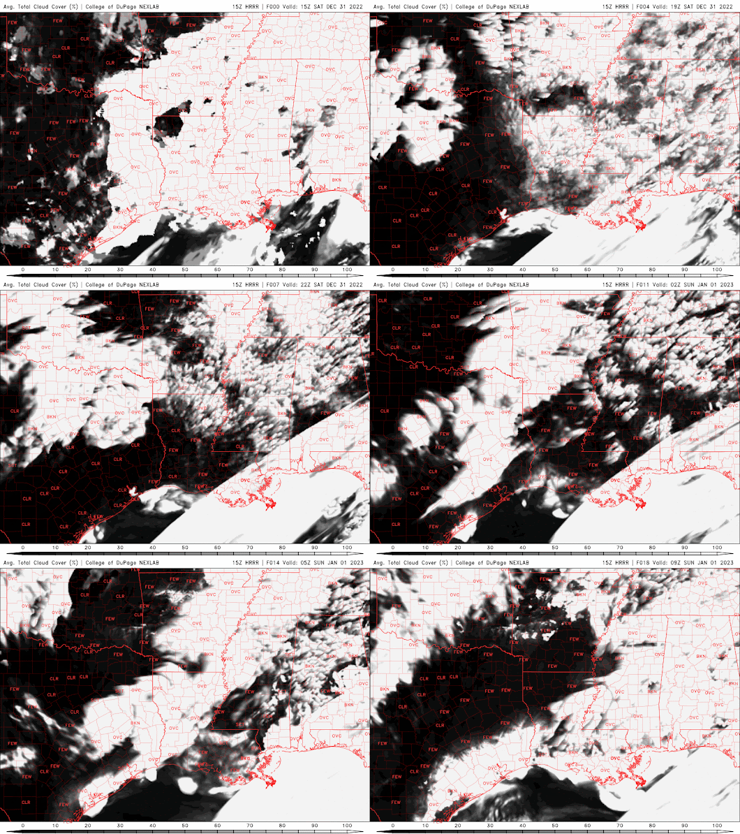
Mild temps with some mid-level clouds. Could see the fog return so drive with caution. No rain. Here is the High-Resolution Rapid Refresh Model for simulated radar and satellite.
Saturday, December 31, 2022
Thursday, November 24, 2022
Thursday, November 17, 2022
Wednesday, November 16, 2022
Colder than average temperatures till Nov 25th.
Colder than average weather returns to Southeast Louisiana till November 25th. Then a warmer than average trend takes over.
Saturday, August 6, 2022
Tropical Update 8/6/22
NHC has the yellow crayon out. 20% chance of a tropical wave coming off Africa to develop in the next 5 days. No model support for any development. Just something to watch. The MJO pulse is favorable for convection in that area. But the dry air and dust is still there. Stay tuned. I’ll try and post some model runs and have some discussion on this later. #SELAWX
Tropical Weather Outlook
NWS National Hurricane Center Miami FL
800 AM EDT Sat Aug 6 2022
For the North Atlantic...Caribbean Sea and the Gulf of Mexico:
1. Eastern Tropical Atlantic:
A tropical wave is forecast to move off the west coast of Africa later this weekend. Environmental conditions are expected to be conducive for some gradual development of this system while it moves westward across the eastern and central tropical Atlantic during the early to middle part of next week.
* Formation chance through 48 hours...low...near 0 percent.
* Formation chance through 5 days...low...20 percent.
Friday, July 29, 2022
More Of The Same 07/29/22
Summer continues with the hot and muggy conditions with chances of showers and storms especially in the afternoon. @SELAWX
Sunday, July 24, 2022
Typical Summer Pattern Continues
Typical Summer time pattern. Temps will be near average with lows in the 70s and highs in the lower to middle 90s, and there will be scattered showers and storms popping up from the late morning into the early evening hours tomorrow. #SELAWX
Friday, July 22, 2022
7/22/22 Showers and HRRR Model
This afternoon's showers on the satellite video with radar overlay and the HRRR model through tomorrow afternoon. Showing clouds and simulated radar
Wednesday, July 20, 2022
Heat Advisory 7/20/22
A Heat Advisory in effect from 11AM to 7PM CDT. A passing shower or storm could bring temporary relief but won't be much. Take precautions if you plan to be outdoors for an extended period. Drink lots of water and take frequent cool down breaks. Check on the elderly.
Thursday, July 14, 2022
Monday, July 11, 2022
Rainmaker for the Northern Gulf Coast
NHC has the Northern Gulf highlighted for potential tropical development of 30% in the next 5 days. Regardless of cyclonic formation there is an increased rain chance associated with this stalled out frontal system. So here is the model estimated total rainfall for the next 5 days. EURO and GFS. #SELAWX
EURO 5 Day Rain Totals
Sunday, July 10, 2022
Upper Gulf Development Possible
Computer model runs are starting to consistently sniff out a North Gulf Low pressure forming in about the 7 days' time frame. July 17-18ish. It doesn’t look like much more than a rain maker. So, all interest from the upper Texas coast to the central Florida panhandle need to watch this closely. GFS, EURO, and the ICON are all in agreement.
EURO
GFS
ICON
Friday, July 8, 2022
Wide Variety of Weather This Weekend
Wednesday, July 6, 2022
Afternoon Showers and Chance For Severe Weather
Tuesday, July 5, 2022
Today’s Chance For Severe Weather
Monday, July 4, 2022
Afternoon Shower Starting Early. Tropics Are All Clear.
A few showers have popped up. Could see more with some locally heavy. Hopefully they keep things cool and clear out for a nice cool evening.
Tropics are all clear as we move into an unfavorable MJO phase that has convection suppressed.
Sunday, July 3, 2022
Afternoon Thunderstorms
Afternoon thunderstorms pulling up from the Gulf of Mexico this afternoon. Stay weather aware. Some could produce local street flooding and impaired driving conditions. Stay safe.
Saturday, July 2, 2022
It’s Hot Out There!
It’s hot out there today. Take heat precautions. Drink plenty fluids and take frequent breaks. #SELAWX
Tropical Storm Colin Forms
5am EDT 2 July -- Overnight surface obs, satellite, & radar data indicated Tropical Storm #Colin developed with 40 mph winds. TS Warnings have been issued for parts of the South & North Carolina coasts as the storm moves NE along the shore this weekend.
Here are the latest Spaghetti model plots.

Friday, July 1, 2022
New Invest 96L /Texas Invest 95L Is No More / TS Bonnie Making Landfall
Surprise! Or not. The blob I was watching off the Carolina coast has gotten the attention of the NHC which has now designated it Invest 96L. Nothing more than a blobby rain maker. So, watch out if you're in Georgia and the Carolina's, Flooding rains are a possibility.
Here are the models for Invest 96L
INVEST 95L Is No More
TS Bonnie Moving Ashore
TS Bonnie is making land fall down along the Costa Rica/Nicaraguan Eastern coast. Winds 40 MPH and she's moving fast. 20mph. Weak Tropical Storm. Pressure is 1005mb.
Will she remain intact and make the cross over to the Pacific? We will see. So, stay tuned.
Peace Out!
Whitney
Thursday, June 30, 2022
Flash Fload Warning Tangipahoa Parish
Flash Flood Warning Tangipahoa Parish including Greensburg LA, Montpelier LA and Pine Grove LA until 6:45 PM CDT
Flash Flood Warning for New Orleans
Flash Flood Warning issued for New Orleans metro area. High rainfall rates in Metairie, Gretna and the CBD being reported. #SELAWX
USAF Hurricane Hunters enroute to INVEST 95L
USAF Reserve Hurricane Hunter Aircraft is headed back to the Western Gulf to update us on Invest 95L. Still looks like just an area of low pressure. I don't think the winds will support any upgrading of status. But we will see what they find. #SELAWX
PTC2 6/30/2022 UPDATE
Two hurricane hunter aircraft are enroute to PTC2. They will once again be looking for signs of a closed circulation. Winds are still at 40mph and it's still moving fast off to the West at 20mph. so any rapid strengthening is still out of the question.
POWERFUL SOLAR FLARES IN PROGRESS
POWERFUL SOLAR FLARES IN PROGRESS : New sunspot 4366 has an unstable 'delta-class' magnetic field that is crackling with strong...

-
It’ll be HOT! Today, tonight and Saturday. Also chance for severe storms on Saturday. Stay weather aware. #SELAWX
-
This Martin Luther King Jr. weekend will be a bit chilly with Sunday being the coldest day of the weekend. Temperatures will only warm int...
-
POWERFUL SOLAR FLARES IN PROGRESS : New sunspot 4366 has an unstable 'delta-class' magnetic field that is crackling with strong...


.jpg)


.png)


.png)
