Flash Flood Warning Tangipahoa Parish including Greensburg LA, Montpelier LA and Pine Grove LA until 6:45 PM CDT
Thursday, June 30, 2022
Flash Fload Warning Tangipahoa Parish
Flash Flood Warning Tangipahoa Parish including Greensburg LA, Montpelier LA and Pine Grove LA until 6:45 PM CDT
Flash Flood Warning for New Orleans
Flash Flood Warning issued for New Orleans metro area. High rainfall rates in Metairie, Gretna and the CBD being reported. #SELAWX
USAF Hurricane Hunters enroute to INVEST 95L
USAF Reserve Hurricane Hunter Aircraft is headed back to the Western Gulf to update us on Invest 95L. Still looks like just an area of low pressure. I don't think the winds will support any upgrading of status. But we will see what they find. #SELAWX
PTC2 6/30/2022 UPDATE
Two hurricane hunter aircraft are enroute to PTC2. They will once again be looking for signs of a closed circulation. Winds are still at 40mph and it's still moving fast off to the West at 20mph. so any rapid strengthening is still out of the question.
Wednesday, June 29, 2022
1st Mission into Invest 95L
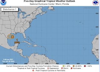
First recon mission into Invest 95L. Air Force Reserve C-130J is in the Western Gulf of Mexico right now finding what I had expected. A loosely organized area of broad low pressure. There seems to me to be some signs of organization happening so this may get to Tropical Depression status or get a PTC label soon. #SELAWX
PTC2 6/29/22 Update
Taking a look at PTC2 this morning. It’s moving off to the West at break neck speed. 30mph. I don’t see it developing at this speed. It’s out running it’s self. Winds still at 40mph and still an open circulation so it’s not getting a name. Land interaction and it’s forward motion are preventing it from wrapping up.
Tuesday, June 28, 2022
Hurricane Hunter Aircraft,
TEAL71 (97-5304) a Air Force Reserve C-130J just finished up a mission into
PTC2 and still cannot find a closed circulation. So the 10:00AM update remains
the same. Max winds of 40mph. It seems to be moving fairly quickly to the West
at 23mph. The fast forward movement is not conducive to any rapid development.
So this should continue to be a sloppy system. Especially with the upcoming
land interaction. We may not see further development if this continues. #SELAWX
The Gulf blob is now Invest 95L
Monday, June 27, 2022
PTC 2
Invest 94L is now Potential Tropical Cyclone 2. (PTC2). With Tropical Storm Force Winds of 40mph but no closed circulation. Hmm…. This seems to be the trend this season. 🥹
Weather Recon Mission 1 is in Invest 94L. NOAA P3 Orion, "Kermit." Looks like they found tropical storm force winds. But is there a closed circulation? It doesn't look like it. So we will soon see if they name it. Regardless, Tropical Storm warnings will be up soon for the Leeward Islands and Venezuelien coast.
NOAA2 Mission #1 into INVEST
Type: Low-level Reconnaissance | Status: In Storm
Watching Invest 94L Today
Lowriding tropical wave with signs of development today. Hurricane Hunter Aircraft will be investigating this later today. Could see signs of low level circulation. This may get Tropical Depression status or could we see our second TS of the season. Stay Tuned!
POWERFUL SOLAR FLARES IN PROGRESS
POWERFUL SOLAR FLARES IN PROGRESS : New sunspot 4366 has an unstable 'delta-class' magnetic field that is crackling with strong...

-
It’ll be HOT! Today, tonight and Saturday. Also chance for severe storms on Saturday. Stay weather aware. #SELAWX
-
This Martin Luther King Jr. weekend will be a bit chilly with Sunday being the coldest day of the weekend. Temperatures will only warm int...
-
POWERFUL SOLAR FLARES IN PROGRESS : New sunspot 4366 has an unstable 'delta-class' magnetic field that is crackling with strong...


.png)

.png)
