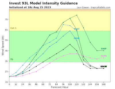
Our Red Crayon area has now been designated INVEST 93L. So we are now getting spaghetti plots. Remember there is no center for the models to lock in on so the plots will change. There is some meandering forecast over and around the Yucatan for the next couple of days. So do not rely on the lines of the plots yet. The area of concern, is the upper and Eastern Gulf Coast from central Louisiana to Miami. This includes the entire West coast of Florida and the Keys. Of course an upper Gulf Coast landfall could be catastrophic as there is the chance for rapid intensification. While it is more likely to be a minimal hurricane. PLEASE MAKE PLANS FOR EVACUATION! Have some where to go. Listen to your local officials for guidance. With that said. Here is the latest from the NHC. Also the EURO ensembles, Operational Intensification Plots, GFS Ensembles, and the Operational Mosaic. We should have more hurricane specific modeling out shortly. #SELAWX
Friday, August 25, 2023
POWERFUL SOLAR FLARES IN PROGRESS
POWERFUL SOLAR FLARES IN PROGRESS : New sunspot 4366 has an unstable 'delta-class' magnetic field that is crackling with strong...

-
It’ll be HOT! Today, tonight and Saturday. Also chance for severe storms on Saturday. Stay weather aware. #SELAWX
-
POWERFUL SOLAR FLARES IN PROGRESS : New sunspot 4366 has an unstable 'delta-class' magnetic field that is crackling with strong...
-
This Martin Luther King Jr. weekend will be a bit chilly with Sunday being the coldest day of the weekend. Temperatures will only warm int...


.png)