Sunday, February 1, 2026

POWERFUL SOLAR FLARES IN PROGRESS

 POWERFUL SOLAR FLARES IN PROGRESSNew sunspot 4366 has an unstable 'delta-class' magnetic field that is crackling with strong solar flares. Earlier today it produced a M7-X1-M6 flare that collectively lasted more than 6 hours. X marks the spot in this snapshot from NASA's Solar Dynamics  Observatory: 

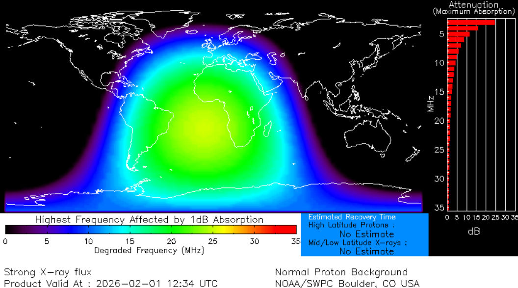
Extreme ultraviolet radiation from the flare ionized the top of Earth's atmosphere. This, in turn, caused a shortwave radio blackout centered on the South Atlantic, touching the edges of South America and Africa: map. Ham radio operators may have experienced loss of signal below 20 MHz for hours around 1230 UTC.

Is a CME heading for Earth? The jury's still out. First-look data suggest "no," but this conclusion may be overturned by fresh data from NOAA and SOHO coronagraphs. Stay tuned.

Source: spaceweather.com

Friday, January 23, 2026

EXTREME COLD WATCH


EXTREME COLD WATCH: Wind chills Sunday night and Monday night fall into single digits and teens. Bring your pets and plants inside and check on your neighbors! Everyone needs to have pipes protected as well.

Sunday, January 18, 2026

12PM 1/18/2026


12PM 1/18/2026:☀️ Beautiful day out there today, but chilly! Temps in the mid/upper 40's.
🥶 Cold tonight! Several hours of below freezing temperatures along the I-10/12 corridor, south into the Atchafalaya Basin. Bundle up in the morning! Another cold one Mon night/Tue morning. Take precautions & stay warm!

Saturday, January 17, 2026

This Martin Luther King Jr. Weekend


 This Martin Luther King Jr. weekend will be a bit chilly with Sunday being the coldest day of the weekend. Temperatures will only warm into the mid 50s tomorrow after starting out in the 40s and skies will be mostly cloudy. Occasional light rain showers will also affect areas mainly south of I-10 along the MS and LA coasts. Late Saturday night, the rain may briefly change over to some snow flurries on the MS coast, but no accumulation is anticipated. Sunday will be sunny and cool with the day starting out in the upper 20s and lower 30s. Highs will struggle to reach 50 in most locations. Monday will continue to the cool trend with lows once again falling into the upper 20s and lower 30s, but highs should warm to the mid to upper 50s by the afternoon beneath a mostly sunny sky.

Tuesday, January 13, 2026


Jan 13, 2pm -- Expect chilly to cold overnight low temps the next few days.

Coldest will be early Friday morning. First graphic is our current forecast; Second graphic is the reasonable worst cast to keep in mind.
This is still a few days away, so stay tuned for any adjustments.

Tuesday, November 19, 2024


The rain has mostly moved out of SE LA with only some lingering showers remaining. There is still the chances for locally heavy rain and some flooding over Coastal MS. Otherwise, sun should return with temperature in the lower 80s.

.TONIGHT...Mostly clear. Cooler with lows around 60. Northwest
winds 5 to 10 mph. 
.WEDNESDAY...Sunny, cooler with highs in the lower 70s.
Temperature falling into the mid 60s in the afternoon. Northwest
winds 15 to 20 mph with gusts up to 30 mph. 
.WEDNESDAY NIGHT...Mostly clear. Cooler with lows in the upper
40s. North winds 15 to 20 mph. 
.THURSDAY...Sunny. Highs in the mid 60s. Northwest winds 10 to
15 mph. 
.THURSDAY NIGHT...Clear. Lows in the mid 40s. West winds 10 to
15 mph. 
.FRIDAY...Sunny. Highs in the lower 60s. 
.FRIDAY NIGHT...Mostly clear. Lows in the mid 40s. 
.SATURDAY...Sunny. Highs in the lower 60s. 
.SATURDAY NIGHT AND SUNDAY...Mostly clear. Lows around 50. Highs
in the mid 70s. 
.SUNDAY NIGHT THROUGH TUESDAY...Partly cloudy. Lows in the mid
60s. Highs in the upper 70s. 

Wednesday, November 13, 2024

Invest 99L

The NHC has issued an Invest for the area of disturbance weather in the Caribbean. Invest 99L. It is predicted the undergo tropical cyclone genesis in the next few days and form a depression as conditions are favorable for development. Still very early and since nothing has formed the computer modeling is low accuracy in the long term. But ensemble trending has it pulling up into the Gulf of Mexico and the trend is a pull to the East. Unfortunately, this is looking more like a Florida storm. Everyone from the panhandle to the keys should be keeping an eye on this and preparing for tropical weather or hurricane impacts as soon as next week.  Here are the operational model mosaic, ensembles for GFS, EURO, Canadian as well as the intensity mosaic. #SELAWX


Thursday, November 16, 2023

Three Day Forecast

 Three day forecast and the coastal flood advisory. Unfortunately the little rain we’ve gotten has not put a dent in the drought. Nor has it done anything to help put out the marsh fires burning underground.


Monday, November 13, 2023

Rain Rain Rain

 It’s going to be rainy for a few days. It’ll clear out Wednesday. Drive safe! #SELAWX


Thursday, September 7, 2023

Storms Diving South

 9/7/23 5:25pm Storms diving South across the area with a cold front. Local flooding a possibility. Stay weather aware! #SELAWX


Saturday, August 26, 2023

RAPID INTENSIFICATION SCENARIO!

 RAPID INTENSIFICATION SCENARIO! The hurricane specific models had locked on with the formation of a center of circulation and it’s not good. We will see a CAT3 or 4 major hurricane in the Gulf of Mexico making landfall on the Florida panhandle. Those in the path of this storm make your evacuation plans now. Have a place to go. You have till Tuesday. This is going to be a killer storm. #SELAWX


Friday, August 25, 2023

Invest 93L

 Our Red Crayon area has now been designated INVEST 93L. So we are now getting spaghetti plots. Remember there is no center for the models to lock in on so the plots will change. There is some meandering forecast over and around the Yucatan for the next couple of days. So do not rely on the lines of the plots yet. The area of concern, is the upper and Eastern Gulf Coast from central Louisiana to Miami. This includes the entire West coast of Florida and the Keys. Of course an upper Gulf Coast landfall could be catastrophic as there is the chance for rapid intensification. While it is more likely to be a minimal hurricane. PLEASE MAKE PLANS FOR EVACUATION! Have some where to go. Listen to your local officials for guidance. With that said. Here is the latest from the NHC. Also the EURO ensembles, Operational Intensification Plots, GFS Ensembles, and the Operational Mosaic. We should have more hurricane specific modeling out shortly. #SELAWX


Thursday, August 24, 2023

Gulf of Mexico Watch


 IMPORTANT UPDATE: Orange area in the Gulf of Mexico by the beginning of next week. For those that are saying this is only going to be a Tropical Storm. The possibility of a rapid intensification scenario does exist in the Gulf of Mexico as water temperatures are very hot. Although unlikely it’s still a possibility. This is going to happen fast and everyone needs to be prepared. Model guidance is hinting at a Florida peninsula landfall. But upper Gulf is not eliminated yet. It’s just to early to tell. Once a center forms we will have much better consistency on guidance. But then we will only have a few days, if that. So everyone on the Gulf coast need to have a plan. Also the Atlantic East coast as some models have a Keys, Homestead, Miami component to the predicted path. #SELAWX 


Tuesday, August 22, 2023

Keeping an Eye on the Gulf

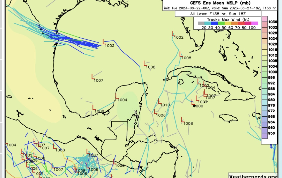
 We need to watch the CAG (Central America. Gyre) for a pull up of a Low pressure system. The ensembles are hinting at tropical cyclonic development in the Bay of Campeche, Yucatan, Western Caribbean area. Here are the blended composite models NCEP. They combine EURO , CMC ensembles, Also the EURO and GFS ensembles. 5 to 10 days out.


#SELAWX

Saturday, August 19, 2023

Tropics Are Heating Up

 The Tropics are heating up and so is SE Louisiana. Excessive Heat Warnings are in effect for most of SELA. In the tropical Atlantic we are watching 3 tropical waves for development. All three have invest status now. 98L, 99L, 90L. Then there is a wave entering the Gulf of Mexico and will bring rain to Florida and SE Texas. Some model support for it to spin up just before landfall to a TD or minimal TS in SE Texas. 98L is going to spin off into the Atlantic and may get the Emily name as it is already looking like a TD. 99L could bring rain to the Northern Lesser Antilles and 90L could bring rain to the Lesser Antilles and Hispaniola as it enters the Caribbean and turns North. Try to Stay Cool!


Friday, August 18, 2023

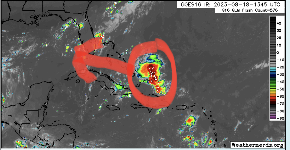
Tropical Wave

This weekend we have a tropical wave that will enter the GOM. It’s predicted to be moving fast and not have time to develop much. Current predictions have it at a strong tropical depression or minimal tropical storm strength at landfall in East Texas. This is mostly a rain event for South Florida and Southeast Texas. Here are the EURO and GFS ensemble models. Be sure to stay weather aware. #SELAWX


Sunday, August 13, 2023

Keeping an Eye onThis


 NHC is highlighting this area with a 20% chance of tropical cyclone formation in the 7 day forecast. It has little model support but we will just have to wait and see. The MJO will be coming back into a favorable phase over the Atlantic ITCZ. Aug 16 - Sept 10. The SAL will be weakening as well. So it could be on like Donkey Kong. 


Tropical Weather Outlook

NWS National Hurricane Center Miami FL

200 PM EDT Sun Aug 13 2023


For the North Atlantic...Caribbean Sea and the Gulf of Mexico:


1. Eastern Tropical Atlantic:

A broad area of low pressure is forecast to develop during the 

middle part of this week over the far eastern Atlantic between the 

Cabo Verde Islands and the west coast of Africa. Some slow 

development of this system is possible later this week as it moves 

west-northwestward or northwestward across the eastern Atlantic.

* Formation chance through 48 hours...low...near 0 percent.

* Formation chance through 7 days...low...20 percent.

Monday, July 17, 2023

Possible Tropical Development 7/17/23

 The Ensemble Models are indicating a strong possibility of cyclonic development in about 5 days as a strong tropical wave is coming off the African continent into the Eastern Atlantic. While there is a good model signature for possible development. There is less support for it holding together in the 5 to 10 day. So we may see the NHC yellow crayon for this area soon. But at this point it’s just an area to watch.  #SELAWX


Friday, July 14, 2023

Heat Warning 7/14/23

 A heat advisory is in effect on Friday from 10 AM to 8 PM. Dangerous heat index values from 108 to 112 are expected in southeast Louisiana and southern Mississippi. Take frequent breaks in the shade or air conditioning, drink plenty of water, even if not thirsty, check on elderly, ill neighbors and family members, bring pets indoors or provide shade and plenty of water.


POWERFUL SOLAR FLARES IN PROGRESS

  POWERFUL SOLAR FLARES IN PROGRESS :  New sunspot 4366 has an unstable 'delta-class' magnetic field that is  crackling  with strong...